The Mission of Hurricane Hunter
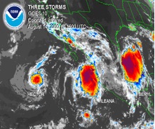
The primary mission of the 53rd Weather Reconnaissance Squadron (53rd WRS) is to conduct tropical storm reconnaissance. The 53rd WRS is aligned under the 403rd Reserve Wing located at Keesler AFB in Biloxi, Mississippi. Although the airplanes and people are Department of Defense assets the units “primary tasking” command is the Department of Commerce. Although a strange set-up it has worked well. Tropical reconnaissance is governed by the National Hurricane Operations Plan. This plan specifics that the 53rd WRS will support 24 hour a day continuous operations and have the ability to fly up to 3 storms at a time with a response time of 16 hours. I am sure you thinking, 3 storms a day, that would never happen! Well, our AOR is not just the Caribbean and the Atlantic it actually extends from the Mid-Atlantic (55W Longitude) to the International Dateline in the Pacific.
Since the 53rd WRS is tasked to fly three storms, twice a day, there is a necessity for ten full-time aircrews and ten part-time. Many of the part-timers are part of the civilian work force and hold a wide array of jobs including airline pilots, school teachers, realtors, you name it.
They come to the base a couple of times every month to train and will fly recon missions when available. The 53rd WRS flies the WC-130J with a five person crew element to include a pilot, co-pilot, navigator, aerial reconnaissance weather officer (ARWO), and a Weather Loadmaster.
Low Level Investigation:
When a storm is beginning to form, the National Hurricane Center will send the 53rd WRS to investigate whether the winds are blowing in a counterclockwise rotation therefore indicating a “closed system”. This mission is flown from 500 – 1500 feet above the ocean surface; the ARWO will constantly monitor the ocean waves in order to determine the wind speed and direction from the sea state. The low-level wind and pressure fields will provide an accurate snapshot for the Hurricane Center Forecasters. Once it is determined that there is a circulation within the disturbance, the mission will transform into a “fix” mission.
Fix Mission:
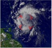
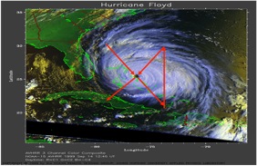
The “fix” mission is where the ARWO will direct the crew to the true center of the storm. In order to get a good overall look at the storm the unit flies the storm using an alpha pattern (see image below), which consists of intercardinal headings with legs 105 nautical miles in length. This alpha pattern is repeated 2 times during one mission.
During flight weather data is continuously collected and sent directly to the National Hurricane Center via satellite communications. Since the WC-130J is not equipped for aerial refueling, the alpha pattern will continue until “bingo” fuel is reached or the National Hurricane Center has received all the information it needs. We enter major hurricanes (category 3 or above) at 10,000 feet. While penetrating the eyewall, a weather instrument, called a dropsonde, is released to determine the maximum winds at the surface and than another “sonde” is released in the eye to detect the lowest pressure at the surface. After exiting the eye the ARWO creates a vortex message that includes the exact latitude and longitude of the center as well as maximum winds, maximum temperature and minimum pressure. For more information where to get their data and how to read it, click here.
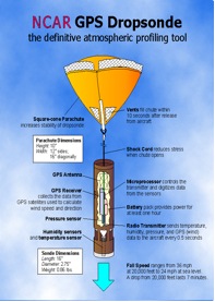
The graphic above illustrates what a sonde looks like. Sondes collect the same vertical data that weather balloons over land do just they go down instead of going up. This instrument gathers weather data including wind direction and speed, pressure, temperature, and humidity from the planes altitude to the waters surface creating a vertical profile of the atmosphere
Why they do what they do:
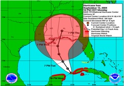
So, why do they do this? The impact of hurricane hunter data is drastic – up to 30% more accurate according to the National Hurricane Center. The 30% metric sounds great, but what does it really mean to the public and the government? Below was a four-day forecast issued by the National Hurricane Center of Hurricane Ivan with the white bubble indicating their margin of error in the forecast. Without recon data the forecast would have a margin of error similar to the red bubble and with the estimated cost to evacuate one U.S. coastal mile at one million dollars the savings can be enormous. Indirectly, the Hurricane Hunter’s data save lives. Since people believe the forecast, they heed warning areas and evacuate the affected areas. Without the only operational hurricane reconnaissance unit in the world flying into storm every season, the negative impact on forecast accuracy could be devastating.
Buoy Drops:
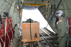
A mission we are sometimes tasked to do during the hurricane season is dropping various weather buoys in the path of oncoming hurricanes and tropical storms. We load the required buoys on the aircraft and drop the buoys via parachute at predetermined locations. It’s an exciting mission as we don’t often get to open the back of the plane up in flight!
Winter Storm Mission:
So, what do we do in the winter? The 53rd WRS also collects data for winter storms which has proven to be very valuable to the National Weather Service. The goal is to release the dropsonde as high as possible in the atmosphere and ahead of the storm extending the network of weather data over the water. This data drastically increases the accuracy of computer weather forecasts for nor’easters and pacific winter low pressure systems. The Hurricane Hunters use the month of February to fly Pacific storms from Elmendorf AFB, Alaska or Hickam AFB, Hawaii.
Research Missions:
Most folks know that both the 53rd WRS and NOAA perform flights into tropical systems. One of the biggest differences between our missions is that we usually collect data for operational meteorology use while NOAA flights are usually for research use. But occasionally we do get to do research missions as well. This past year we participated in the joint Tropical Cyclone Structure research project with NOAA, the U.S. Navy, and the countries of Taiwan, Germany, and Japan flying our missions out of Guam and Japan. The research missions are often exciting and interesting but the work we do is much the same as we do on a daily basis, launching instruments like sondes and buoys into tropical or mid-latitude systems to collect data for research meteorologists.
Tactics:
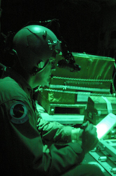
As a U.S. Air Force unit flying one of the most capable tactic airlift platforms in the inventory, our crews are also required to maintain proficiency it tactical airlift operations. This includes training in safe combat flight operations, combat offload of cargo, and flight operations under night vision goggles (NVGs).